Which Cupix Alternative Fits a Site Without a BIM Model?
Every valuation asks you to prove what was built, and every pour hides more of it. SpatialSense writes your progress evidence from two dated walks of the site, with no BIM model needed, and keeps the scans and drone flights beside them. Try it on one of your own sites for 30 days, with no card details.
Updated 9 November 2026 · Written by Kodifly, the company that makes SpatialSense
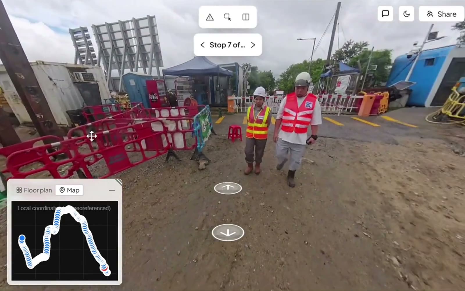
Pinning an issue to the spot in a 360° walk, in SpatialSense.
What Cupix users run into, and how SpatialSense helps
Most sites don’t have a BIM model that is current enough to measure against, yet the monthly valuation still wants proof of what was built. If you are the one assembling that proof from photos and memory, these are the problems Cupix users and Cupix’s own pages describe, in plain words, with what SpatialSense does about each one.
What Cupix’s own pages say
Progress measurement waits for a BIM model
Cupix’s own progress-tracking page says you need BIM models for its AI to measure progress, and that when the model or the schedule changes you send the updated file to Cupix.
Stated on Cupix’s progress-tracking page
How SpatialSense handles it
SpatialSense writes a station-by-station progress report from two dated walks, tied to the images it was read from, so a site without a model still gets written evidence. If you keep a workplan, the report also shows each milestone’s status against it, and the AI only proposes: a person approves every finding. When you do have an IFC model, it sits beside the scan as an overlay.
What Cupix’s own pages say
Weeks of setup before the first report
Cupix says setting up its progress tracking can take four to six weeks, with its customer success team configuring the connections alongside you.
Stated on Cupix’s progress-tracking page
How SpatialSense handles it
With SpatialSense you set up your own site in the 30-day trial: upload the plans and 360° panoramas from your current camera in the browser, and the side-by-side view works from the second dated walk. If you want Trace, the capture app, Kodifly sets it up when you book a demo, and a person at Kodifly is on hand around the clock either way.
What users report
Capturing the site takes real effort, every week
A construction reviewer says capturing a large number of 360° photos on site still takes a lot of effort, and Cupix recommends a capture at least once a week, so that effort comes round again every week.
Reported on SoftwareFinder (2022); weekly capture recommended on Cupix’s page
How SpatialSense handles it
Trace records from a helmet or from a car, so the people already walking or driving the site capture it as they go, with no survey crew. For a zone that changes by the hour, fixed LiDAR stations scan it every 15 to 30 minutes with nobody on site.
What users report
A long learning curve, and help that didn’t resolve it
Some reviewers say it takes a long adjustment period before you can use all the features, find the editor confusing, and say the tutorials and support didn’t solve their problem. Most of these reviews are a few years old.
Reported on SoftwareFinder (2018–2023) and the WGAN forum
How SpatialSense handles it
Support for SpatialSense is one-to-one with a person at Kodifly, 24 hours a day, in your language where Kodifly has people, so a question on site gets answered while you are still standing there.
What Cupix’s own pages say
The price depends on the project, and comes from sales
Cupix says its progress-tracking price takes into account the total project value and the square footage, and its pricing link leads to a contact form for the sales team.
Stated on Cupix’s progress-tracking and pricing pages
How SpatialSense handles it
SpatialSense prices per site with unlimited users, and the prices are on the pricing page. Walks, scans, drone flights and the side-by-side view are on every plan, and you can try all of it for 30 days with no card.
What you are after is a valuation meeting where the evidence is already on the table: dated walks, a written report and the images behind every line, so you are the one with the record instead of the one explaining the gaps.
Is SpatialSense the right Cupix alternative for you?
SpatialSense is built for site teams who have to prove progress every month without a model they can measure against. It turns the walks you already do into dated, image-backed evidence, keeps scans and drone flights in the same project, and you can see it on one of your own sites inside 30 days, with no card and no setup project.
SpatialSense fits if
You have no BIM model, or not one you trust. Any two dates open side by side from one locked viewpoint, and a station-by-station progress report is written from two dated walks, tied to the images it was read from.
Your site produces walks, scans and drone flights. They sit in one project on every plan, and fixed LiDAR stations can scan a zone every 15 to 30 minutes with nobody on site.
People outside your company need the record. Share links open without a login and can be revoked, and every plan has unlimited users, so the client and the consultants never add to the bill.
You want to try it before a sales call. The 30-day trial covers the full platform with no credit card, and support is one-to-one with a person at Kodifly, 24 hours a day.
How does SpatialSense compare with Cupix?
The main difference is where the progress evidence comes from. Cupix measures it against a BIM model and a schedule, so it depends on both being kept current. SpatialSense writes it from two dated walks of the site, so the evidence comes straight from what was captured.
SpatialSense
Cupix
360° walks
The Trace app with an Insta360 X4 or X5 on a helmet or a car
A consumer 360° camera on a hard hat or a stick, such as the Insta360 X5 or X4; cloud AI rebuilds a 3D map
Laser scans and drones
Scans from any maker as E57, LAS, LAZ, PCD or PLY, drone flights, and fixed LiDAR stations that scan a zone every 15 to 30 minutes with nobody on site
Drone images through SkyMap; external point clouds accepted, but the formats are not published
BIM model
IFC models, including Revit models exported to IFC, open in the browser beside the point cloud and the 360° walks, with the model overlaid on the scan so you see the as-built next to the design
From BIM 360, Forma, Revizto or Navisworks, with the formats not named; BIM overlay on the captures
Progress evidence
Any two dates side by side from one locked viewpoint, and a station-by-station PDF report from two dated walks, tied to the images
SiteInsights against the schedule (P6, Microsoft Project, WBS or CSV) and the BIM model, which it needs to measure automatically
Issues
Pinned in the walk or scan with an owner and a due date, answered from the Konnect app, with WhatsApp alerts in the recipient’s language
RFIs and punch lists through Procore
People outside the paid team
Unlimited users, and revocable share links that open without a login
PDF export for people without Cupix access; share links and guest seats are not published
Pricing and trial
Per-site pricing with unlimited users (current prices), and a 30-day trial with no credit card
The pricing link leads to a contact form, and the terms of the “Start for free” sign-up are not published
What it looks like in SpatialSense
Any two dates, side by side
Open two walks of the same spot from one locked viewpoint and see what changed between them.
Issues with an owner and a date
Pin a problem to the spot in the walk, assign it, and get the answer back from the Konnect app.
A link your client can open
Send a share link that opens in the browser without a login, and revoke it when the job is done.
Moving from Cupix to SpatialSense
You can test SpatialSense on one site without changing how the rest of your projects run.
Gather the originals. Collect the scans as E57, LAS or LAZ, the model as IFC and the floor plans as PDF, DWG or DXF.
Start the trial. The 30-day trial unlocks the full platform with every feature and needs no credit card.
Upload one site. Put its plans, scans and model in one project and judge it against the Cupix record you know.
Add your 360° walks. Upload 360° panoramas from your current camera in the browser, or book a demo and Kodifly sets up Trace, the capture app that records with an Insta360 X4 or X5 on a helmet or a car. After two dated walks you get the side-by-side view and the progress report.
Bring in the client. Invite the whole team, since users are unlimited, and send the client a share link that opens without a login.
Frequently asked questions
What is the best alternative to Cupix?
SpatialSense. It keeps 360° walks, laser scans from any maker and drone flights in one project, writes a station-by-station progress report from two dated walks without needing a BIM model, and gives your client a share link that opens without a login. Every plan has unlimited users, and you can try the full platform on your own files for 30 days with no card details.
Who are Cupix’s main competitors?
SpatialSense competes with Cupix head on for 360° site documentation. The difference is what each one needs from you: Cupix measures progress against a BIM model and a schedule, while SpatialSense keeps walks, laser scans from any maker and drone flights in one project and writes its progress report from two dated walks. If you have an IFC model, SpatialSense shows it overlaid on the scan.
Does Cupix need a BIM model?
For automated progress measurement, yes: Cupix’s own SiteInsights page says you have to have BIM models for its AI to measure progress. SpatialSense does not need one. Walks, laser scans and drone flights go into the project without a model, any two dates open side by side from one locked viewpoint, and the progress report is written from two dated walks. If you do have an IFC model, SpatialSense shows it as an overlay next to the scan or walk.
What is Cupix used for?
Cupix turns 360° video walks into a 3D digital twin of a construction site, overlays BIM and drawings on it, and, with a model and a schedule, tracks the completion of modelled elements over time. SpatialSense is used to keep the whole site record in one project: 360° walks, laser scans, drone flights, floor plans and IFC models, with issues pinned to the spot and a progress report written from dated walks.
How much does Cupix cost?
Cupix does not publish prices. Its pricing link leads to a contact form, and the terms of its “Start for free” sign-up are not published. SpatialSense has per-site pricing with unlimited users (current prices), a Lite Viewer that is free forever, with no account and no time limit, and a 30-day free trial that unlocks the full platform with every feature and needs no card details.
Can I keep the 360° camera we use with Cupix?
If it is an Insta360 X4 or X5, yes. Those are the cameras the SpatialSense Trace app uses, on a helmet or on a car.
What do Cupix users complain about?
Cupix’s own pages say its progress AI needs a BIM model, that setup can take four to six weeks, and that pricing depends on project value and size through sales. Reviewers on SoftwareFinder also mention the effort of weekly capture and a long learning curve. SpatialSense writes its progress report from two dated walks with no model needed, lets you set up your own site in a 30-day trial with no card, captures from a helmet or a car, and gives you one-to-one support from a person around the clock.
See SpatialSense on your project
Every month you wait is another valuation argued from photos and memory. Start the 30-day free trial on one of your own sites today, with no credit card and unlimited users, or book a demo and Kodifly sets it up with Trace for you. Support comes from a person at Kodifly around the clock.
Cupix: home, about, 360 video to 3D map, BIM verification, drone mapping, spatial hub, collaboration; read 4 November 2026
Cupix: construction progress tracking (SiteInsights) page and FAQ, pricing and contact; read 9 November 2026
Cupix TwinCapture on the App Store; read 4 November 2026
Cupix reviews on SoftwareFinder; read 9 November 2026
We Get Around Network forum thread “Does anyone use Cupix?”; read 9 November 2026
SpatialSense is not affiliated with Cupix. User reports are summarised from public reviews and forum posts; product information accurate as of 9 November 2026. Verify current features and pricing with the vendor.