

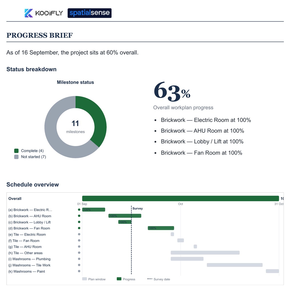
Milestones against your workplan
With a workplan set up, the report opens with milestone status, overall progress and the schedule against the survey date.
Progress tracking without a model
Yes. SpatialSense writes a station-by-station progress report from two dated 360° walks of your site, and ties every line to the image it was read from, so the evidence comes from the walk rather than from a model your project may never have.
You can, as long as the question you need answered is what was built and when. A 360° walk of the site on two dates holds that evidence, and SpatialSense turns the pair into a written progress report, station by station, with each observation tied to the image it came from. If the project has a workplan, the report also opens with milestone status and overall progress against it. A BIM model adds the design as a layer when you have one, but the report does not wait for it.
Automated progress tracking usually compares what a camera sees with a BIM model and a schedule mapped to that model. That works on projects that already run a mature BIM process, but most mid-size jobs are not built that way, so the software waits for inputs that never arrive.
Plenty of projects never get a full coordinated model, and on others it trails the site by weeks. Software that measures against the model can only measure what the model contains.
Aligning a model and mapping a schedule to it is a piece of work in its own right. Contractors have described months of model alignment before the first numbers could be used.
To keep the inputs clean, some vendors send their own technicians or partner crews to capture the site, which puts a booking and a wait between the work and the result.
Your own question is usually simpler than any of that. You want to know what changed on level three since last Tuesday, and you want to show the client without arranging a visit. Answering it takes a dated record of the site and a way to read that record, and a 360° camera on the helmet of someone already walking the floor gives you the record.
With a workplan set up, the report opens with milestone status, overall progress and the schedule against the survey date.
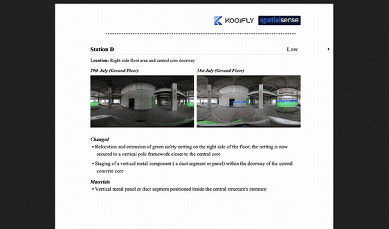
Each station shows the same spot on both dates, then what changed, in plain words.
Run AI on the walk, then confirm or dismiss each detection before anything is raised.
Both approaches record progress, but they start from different places and ask different things of your team before the first result.
| SpatialSense, walk first | Model-first tracking | |
|---|---|---|
| What it needs to start | A 360° camera on a helmet and floor plans for the areas you capture. A workplan if you want milestone status. | A current BIM model and a schedule mapped to its elements. |
| Who captures | Your own team, on the walk they already make. | Often a vendor technician or a partner crew on a booked visit. |
| What you get | A dated walk, any two dates side by side, a written station-by-station report as a PDF and, with a workplan, milestone status against it. | Percent complete by element, once the model and the schedule are aligned. |
| When there is a model | IFC models, including Revit models exported to IFC, open over the scan and the walks. | The model is the basis of every number. |
| Other site data | Drone flights and laser scans from any scanner sit in the same project as the walks. | Varies by vendor. |
| Who can see it | Unlimited users on every plan, plus share links that open without a login. | Licensed users, with outside sharing that varies. |
| How to try it | A 30-day free trial with no card, or a demo on one live site. | Usually a demo and a quoted pilot. |
You need a 360° camera, a phone and the floor plans for the areas you want to track. A model can come later, or never.
Yes. SpatialSense writes a progress report from two dated 360° walks of the same route, station by station, with every observation tied to the image it was read from. The report does not need a model. If you have an IFC model, it opens over the scan and the walks as an extra layer.
A 360° camera on a helmet, from any maker, and floor plans for the areas you capture. The Trace app records the walk on your phone, or you upload the footage in the browser. Laser scans from any scanner, as E57, LAS, LAZ, PCD or PLY, and drone flights can go into the same project when you have them.
Yes, against a workplan. When the project has one, the progress report opens with milestone status, overall workplan progress and a schedule against the survey date, then details each milestone with the evidence behind it. No BIM model is needed for that.
Model-based tracking measures installed elements against a BIM model and a schedule mapped to it, so it needs both before it produces a number. SpatialSense starts from the walk: it compares two dated walks and writes down what changed, with the image beside each observation, which is why it works on projects where the model is missing or out of date.
Yes. Each observation in the report is tied to the 360° image it came from, so you can open that image and see what the report describes. AI proposes and a person approves: nothing is raised without someone confirming it. You can also open the two dates side by side from one locked viewpoint and judge the change yourself.
SpatialSense has per-site pricing with unlimited users (current prices), a Lite Viewer that is free forever with no account needed, and a 30-day free trial of the full platform that needs no card details.
Walk one floor twice this month and read what changed. Start the 30-day trial with no card, or book a demo and we set up your first site with you.