How to Transition to Paperless Site Inspection Software: A 2026 Implementation Guide
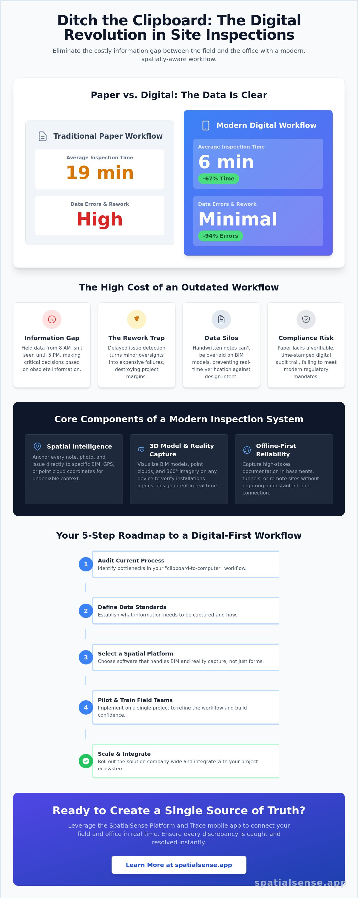
A time-and-motion study of over 2,800 inspections found that using paperless site inspection software slashes inspection time by 67 percent. That is the difference between a 19-minute crawl and a 6-minute sprint. If you're still using clipboards, you're losing hours every single day. Errors drop by 94 percent when you ditch the paper. The data is clear; the old way is costing you more than just time.
You already know the frustration of the manual grind. Illegible handwriting leads to errors. Lost documentation causes high rework costs. Most importantly, notes on a page cannot be overlaid onto a BIM model or a point cloud. It's a fragmented way to work in a high-stakes industry. This guide shows you how to replace manual site inspections with a digital-first workflow that anchors field data to your 3D reality.
We'll walk through the 2026 standard for implementation. You'll learn how the SpatialSense Platform and SpatialSense Trace mobile app create a single source of truth for all site documentation. By the end, you'll know how to integrate 360 imagery with BIM to ensure every discrepancy is caught and resolved in real time.
Key Takeaways
- Eliminate the information gap. Learn why manual reports are obsolete and how a digital-first workflow connects the field to the office instantly.
- Prioritise spatial intelligence over simple forms. Discover why paperless site inspection software needs to handle gigabytes of scan data to be effective in 2026.
- Master the offline-first requirement. Ensure your team can capture high-stakes documentation on remote sites without relying on a constant internet connection.
- Follow a structured 5-step roadmap. Move from a "clipboard-to-computer" audit to a fully integrated BIM and reality capture data architecture.
- Leverage the SpatialSense Trace app. See how to synchronise field capture with the SpatialSense Platform to maintain a single source of truth for every project.
The High Cost of Paper-Based Site Inspections in 2026
Modern paperless site inspection software is not just a digital version of a paper form. It is a digital ecosystem. It connects field data directly to the project's core intelligence. In 2026, relying on physical clipboards is a liability. Paper creates an "Information Gap." A report written on-site at 8:00 AM might not reach the project manager until 5:00 PM. By then, the data is obsolete. The site has changed. Concrete has been poured. The opportunity to fix a mistake has passed. This delay turns minor oversights into major financial drains.
The hidden costs of paper are staggering. Filing cabinets take up expensive office square footage. Manual data entry consumes hours of administrative time and introduces human error. Most dangerously, paper lacks a verifiable audit trail. In a legal dispute, a handwritten note is easily challenged. A digital log is not. This year represents the tipping point where digital audit trails have moved from a "nice-to-have" to a mandatory requirement for large-scale infrastructure. If you can't prove it with metadata, you can't prove it at all.
The Rework Trap: How Bad Data Destroys Margins
The delay between identifying a site issue and resolving it is the primary driver of rework. Paper-based systems create silos. Information stays trapped in a foreman's pocket or a trailer's desk. This prevents proactive deviation detection. You cannot compare a handwritten note against a BIM model in real time. Errors go unnoticed until they become expensive failures. The cost of delay in infrastructure projects is the cumulative financial loss incurred every hour a critical decision remains unmade due to missing or inaccurate field data. High-margin projects are built on speed. Paper is slow.
Regulatory Compliance and the Digital Mandate
The industry is moving toward the "Golden Thread" of documentation. This is a continuous, unbreakable record of a building's lifecycle. Insurance providers now demand verifiable, time-stamped digital logs before they will even quote a policy. They want to see exactly who inspected what, and when. As projects grow in complexity, the industry has shifted toward digital commissioning management systems to ensure every component meets rigorous safety standards. What was once an optional efficiency is now a contractual requirement. Modern paperless site inspection software ensures you meet these digital mandates without adding friction to the field team's workflow. It turns compliance into a byproduct of daily work, rather than an extra chore.
Core Components of a Modern Paperless Inspection System
Most teams think digital forms are the final goal. They are wrong. A modern system is about data connectivity, not just replacing a pen with a stylus. True paperless site inspection software functions as a central nervous system for your project. It must handle massive datasets through cloud-native architecture without requiring expensive local hardware. On-site, offline-first capability is non-negotiable. If your software fails in a basement or a remote tunnel, it is a liability, not a tool. Reliability in the field is the baseline for trust.
Context is everything. Every note and photo needs a permanent home within the project's spatial record. Anchoring field data to specific GPS or BIM coordinates provides a level of clarity that paper cannot match. This spatial context allows for automated reporting. It turns raw field observations into professional, formatted PDFs instantly. No more evening data entry. No more manual collation. Reports download as PDF, so the record reaches the rest of the project team without re-typing. You can explore how these features integrate within the SpatialSense Platform to streamline your own site documentation.
BIM and Point Cloud Visualization
A paperless system must handle 3D models. 2D PDFs are a limitation of the past. Browser-native viewers allow field teams to interact with large-scale infrastructure data without lag. Field teams can "see" through walls using BIM overlays on mobile devices. This allows them to identify clashes or verify installations against the design intent in real time. Handling gigabytes of scan data in the palm of your hand is now a standard requirement for high-stakes projects.
360° Imagery and Reality Capture
Standard snapshots leave blind spots. They capture what the inspector wants to see, not necessarily what is there. 360° imagery provides total visibility and superior legal protection. It represents a fundamental shift from taking photos to capturing reality. Integrating this data into the daily inspection workflow provides a complete, immersive record of site conditions. It ensures that every angle is documented, providing a "time machine" for the project that can be revisited long after the walls are closed.
Evaluating Software: Digital Forms vs. Spatial Intelligence
Most digital tools stop at the form. They take a paper checklist and put it on a screen. This is the "Checklist Fallacy." While better than a clipboard, a digital form only provides about 20 percent of the potential value. If your data isn't anchored to a 3D coordinate, it's just a floating observation. Modern paperless site inspection software must offer spatial intelligence. It should allow you to see exactly where a defect sits within a BIM model or a point cloud. Without that visual anchor, your office team is still guessing. They're still hunting through folders to find context.
Performance is the next hurdle. Can the software actually handle the weight of your project? High-stakes infrastructure generates gigabytes of scan data. If the browser lags or crashes when loading a point cloud, the software is useless. You need a platform that streams data intelligently. It should handle massive datasets without requiring high-end hardware in every inspector's hand. Scalability matters too. A tool that works for a single bridge inspection must also function across a nationwide rail network. If the architecture isn't cloud-native, it will buckle under the pressure of enterprise-scale data.
Field adoption depends on User Experience (UX). Field professionals don't have time for complex menus. We use the "three-tap rule." An inspector should be able to open the app, find their location, and start capturing data in three taps or less. Anything more is friction. Friction leads to non-compliance. If the app is too hard to use, the team goes back to paper. Speed and simplicity are the only ways to ensure 100 percent data capture from the field.
Data Consolidation and the Single Source of Truth
Using five different apps for one inspection is a failure. It creates more work, not less. You need one interface that unifies BIM, point clouds, and field notes. Bloated legacy systems often try to do everything but master nothing. They slow down field teams with unnecessary features. Look for a lean, modern alternative that prioritizes the flow of information. A single source of truth isn't a buzzword; it's a requirement for preventing data silos and ensuring every stakeholder sees the same reality.
Security and Cloud Sovereignty
Sensitive infrastructure projects have strict data hosting requirements. You must understand where your data lives. Web-native platforms offer superior version control compared to on-premise software, ensuring everyone works from the latest model. Security isn't optional for construction SaaS. Ask any vendor how your project data is protected against unauthorized access and leaks. This level of security provides the calm, tech-driven certainty that modern project leads demand.
The 5-Step Roadmap to Implementing Paperless Inspections
Transitioning to paperless site inspection software is a strategic overhaul. It is not a simple app download. For complex engineering environments like tunnels or wind farms, you need a methodical approach. A failed rollout wastes money and destroys team morale. You must move from a "clipboard-to-computer" mentality to a digital-first ecosystem. Follow this five-phase roadmap to ensure a seamless transition that sticks.
Step 1: Auditing Your Current Bottlenecks
Identify where data is lost. Is it in the van? On a desk? Trapped in an unending email chain? Most reporting delays happen in the gap between the field observation and the office upload. Interview your field staff. Ask for their #1 frustration. Usually, it is the double-handling of data. Set clear KPIs early. Aim to reduce reporting time by 50 percent or eliminate manual data entry entirely. If you don't measure the pain, you can't measure the gain.
Step 2: Data Architecture
Define your BIM and reality capture requirements before you pick a tool. Your software must speak the same language as your design models.
Step 3: Hardware Selection
Balance mobile portability with 3D viewing needs. A heavy laptop is a burden in a trench. A small phone screen might not render a complex point cloud effectively. Find the middle ground that supports high-resolution spatial data.
Step 4: Running a Successful Pilot
Never roll out new software across every project at once. It is too risky. Choose a high-visibility, low-risk site. This is your laboratory. Gather feedback from two specific groups. Listen to the "tech-skeptic" veterans. They will find the technical flaws you might have missed. Contrast this with the "digital-native" juniors. They will push the limits of the software's speed. Use these insights to refine your inspection templates for real-world conditions before the wider launch.
Step 5: Full Rollout and Training
Incentivize adoption by highlighting the time saved. Show the team that the "three-tap rule" discussed earlier is the new standard for their daily workflow. When they see their reports generated instantly, the resistance will vanish. If you are ready to move beyond the clipboard and anchor your data to reality, start your transition with the SpatialSense Platform to connect your field data to your BIM models today.
Maximising Site Efficiency with SpatialSense Trace
SpatialSense Trace is the engine for your digital transition. It is purpose-built for high-stakes field documentation. This isn't a general-purpose checklist app. It is a specialized tool for engineering teams who need precision. By using this paperless site inspection software, you bridge the gap between the physical site and your digital twins. It replaces the friction of manual reporting with a streamlined, digital-first workflow. You gain control. You gain clarity. Most importantly, you gain time.
A dropped signal no longer costs you a walk. Trace records with no connection and uploads the walk to the SpatialSense Platform as soon as you have signal. The 360 images and issues then open in the browser, placed on the floor plan. This immediate visibility allows project managers to act before errors are buried under the next phase of construction. It positions your team as a lean, modern outfit that prioritizes speed over corporate bloat. You are no longer reacting to yesterday's problems; you are managing today's reality.
Field-to-Office Connectivity
Office engineers shouldn't have to travel to every site to verify progress. Trace enables them to "walk the site" virtually from any standard browser. By unifying point clouds and BIM in a single web platform, every stakeholder sees the same reality. You can overlay mobile logs directly onto the 3D scan data. This consolidation eliminates the need to cross-reference multiple spreadsheets, folders, or disparate apps. It is one view for one truth. Connectivity becomes your competitive advantage.
Future-Proofing Your Inspection Workflow
Your workflow must grow with the industry. As we move through 2026 and beyond, AI-driven deviation detection will become the standard for high-value infrastructure. The SpatialSense platform is already built to support these advancements, including automated progress tracking. It evolves as your project scale increases. Whether you are managing a single substation or a transcontinental pipeline, the architecture remains nimble. Don't get stuck with a legacy system that can't scale or integrate with modern reality capture data. If you are ready to see the future of field documentation and eliminate the high cost of manual errors, book a demo of SpatialSense Trace today.
Take Command of Your Field Data
The era of the clipboard is over. In 2026, relying on manual reports is an operational liability you can't afford. We've established that paperless site inspection software is about more than just digital forms. It is about spatial intelligence. By anchoring field data to BIM and reality capture, you eliminate the information gap that leads to rework and litigation. You gain a single source of truth that keeps your project on track and your margins protected.
SpatialSense, with the Trace capture app, is built for this transition. Built by Kodifly for infrastructure-scale projects, the platform is web-native and requires no complex installation. It seamlessly consolidates BIM, point clouds, and 360 images into one interface. This is the lean, modern alternative to the bloated legacy systems of the past. It is time to empower your field team with a tool designed for the gritty realities of the site. It is time for clarity.
Start your transition to paperless inspections with SpatialSense Trace. Take the first step toward a more efficient, connected, and transparent project today.
Frequently Asked Questions
What is the best paperless site inspection software for infrastructure projects?
SpatialSense Trace is the premier choice for infrastructure because it anchors field data directly to 3D models and point clouds. Unlike generic form builders, it handles the massive datasets required for bridges, tunnels, and rail networks. It is built specifically for high-stakes engineering environments where precision is non-negotiable.
Can I use paperless inspection apps without an internet connection?
Yes, offline-first capability is a critical feature of modern paperless site inspection software. SpatialSense Trace allows your team to capture 360 images and notes in remote areas or deep basements without a signal. All data synchronizes automatically with the cloud platform once you regain a connection.
How does digital site inspection software reduce construction rework?
Digital software reduces rework by providing immediate visibility to office-based teams. When an inspector identifies a deviation, the project manager sees it instantly overlaid on the BIM model. This allows for proactive corrections before the error is buried under the next phase of construction, saving significant costs.
Do I need special hardware to run BIM-integrated inspection software?
You don't need specialized hardware or expensive laptops. Modern web-native platforms stream 3D data efficiently to standard tablets and smartphones. This ensures your field teams can interact with complex point clouds and BIM overlays using the devices they already carry in their pockets.
Is my data safe in a cloud-based site inspection platform?
Cloud-based platforms are significantly safer than physical storage or local spreadsheets. They use encryption and access controls to protect sensitive project data. Unlike a paper clipboard, digital logs can't be lost in a van, destroyed by weather, or misfiled in an office.
How long does it take to transition a construction team to paperless software?
A successful transition happens in phases over several months. A pilot project can be operational in just a few weeks to test templates and hardware. The full rollout focuses on field adoption by prioritizing simple, high-impact workflows like the "three-tap rule" for mobile documentation.
Can I integrate my existing Autodesk or Procore data with SpatialSense?
SpatialSense works with the files those tools already produce, including IFC models, point clouds and PDF drawings, and issues export as PDF reports. Talk to our team about connecting your specific stack. It eliminates the need for manual data entry and prevents the creation of new information silos.
What are the legal benefits of using digital inspection logs over paper?
Digital logs provide an immutable, time-stamped audit trail that is harder to challenge in court. Every entry is GPS-tagged and linked to high-resolution imagery, creating a "Golden Thread" of documentation. This verifiable record offers superior protection against litigation and simplifies the insurance claim process.