One Platform for Point Clouds,
BIM, and 360° Construction Data
SpatialSense brings all construction teams onto one unified platform for smarter infrastructure management
One Platform for Point Clouds,
BIM, and 360° Construction Data
SpatialSense brings all construction teams onto one unified platform for smarter infrastructure management
One Platform for Point Clouds,
BIM, and 360° Construction Data
SpatialSense brings all construction teams onto one unified platform for smarter infrastructure management


Benefits
Why SpatialSense?
After delivering multiple government scale deployments across industries, Kodifly identified what actually works in real world infrastructure projects. SpatialSense brings enterprise grade performance, reliability, and efficiency that has been proven with governments and large organizations. It is now available to a broader market as a scalable subscription service.
Bring all your Spatial Data to one Platform
SpatialSense brings all your PCD, BIM, and 360° image data together in one place, turning scattered files into sorted valuable assets for visualization, analysis, and collaboration; securely saved throughout the project lifecycle.
Bring all your Spatial Data to one Platform
SpatialSense brings all your PCD, BIM, and 360° image data together in one place, turning scattered files into sorted valuable assets for visualization, analysis, and collaboration; securely saved throughout the project lifecycle.
Bring all your Spatial Data to one Platform
SpatialSense brings all your PCD, BIM, and 360° image data together in one place, turning scattered files into sorted valuable assets for visualization, analysis, and collaboration; securely saved throughout the project lifecycle.
Manage Multiple Projects in a Centralized Hub
Easily create, organize, and manage all your projects from a central dashboard. Set up new projects with a guided workflow, update details, assign teams, upload files, and review before publishing. Organize projects into single-level folders, control team visibility, and navigate quickly with sub sections like Site Surveys, Documents, and Analytics.
Visualize, Measure & Compare 3D Data
Visualize and measure your 3D data from point clouds and BIM to 360° images in one real-time environment. Overlay models, validate work against design and schedule through Bim Comparison, and explore your site digitally to clearly understand conditions without needing to be there.
Understand Context without Being There
Collaborate directly on your 3D PointClouds, understand context and work with colleagues like you are there. Attach screenshots, assign priorities, set deadlines, and link tasks. Track progress in real time with a clear issues table, filter by status or priority, and jump straight to the problem in 3D for faster resolution.
Validate Work Against Design and Schedule
Automatically validate your project’s progress and completion rate through AI-powered analytics. Compare site capture against BIM designs helping teams stay on schedule, avoid budget overruns, and keep stakeholders aligned.
Validate Work Against Design and Schedule
Automatically validate your project’s progress and completion rate through AI-powered analytics. Compare site capture against BIM designs helping teams stay on schedule, avoid budget overruns, and keep stakeholders aligned.
Validate Work Against Design and Schedule
Automatically validate your project’s progress and completion rate through AI-powered analytics. Compare site capture against BIM designs helping teams stay on schedule, avoid budget overruns, and keep stakeholders aligned.
Track and Manage Issues
Flag problems directly on your PCDs, surveys, BIM models, or project documents and turn them into actionable tickets. Every issue is tracked in one place with status, priority, and ownership, so nothing gets missed and your team always knows what needs attention next.
Track and Manage Issues
Flag problems directly on your PCDs, surveys, BIM models, or project documents and turn them into actionable tickets. Every issue is tracked in one place with status, priority, and ownership, so nothing gets missed and your team always knows what needs attention next.
Track and Manage Issues
Flag problems directly on your PCDs, surveys, BIM models, or project documents and turn them into actionable tickets. Every issue is tracked in one place with status, priority, and ownership, so nothing gets missed and your team always knows what needs attention next.
Width Profile Tool
See how wide a space really is at any point in your site. Just draw a line, and SpatialSense instantly shows the exact width using your 3D scan data. No guessing, no manual measurements, and no going back on site. It’s an easy way to check clearances, plan changes, and make confident decisions from your desk.
High-Level Features
SpatialSense provides a central project workspace for team and user management, structured project setup, dashboards, site data viewing (including 3D/BIM/360), surveys, documents, analytics, and settings.
Dashboard & Workspace
Central entry point with List/Grid/Map views; single-level folder creation/organization for projects; role-gated actions
Dashboard & Workspace
Central entry point with List/Grid/Map views; single-level folder creation/organization for projects; role-gated actions
Analytics/Kanban
Track project progress, monitor tasks, and analyze performance metrics through interactive boards and visual reports
Analytics/Kanban
Track project progress, monitor tasks, and analyze performance metrics through interactive boards and visual reports
Project & Document Management
Initialize projects with guided metadata, team assignments, and file uploads; Manage them through with automated versioning.
Project & Document Management
Initialize projects with guided metadata, team assignments, and file uploads; Manage them through with automated versioning.
3D Viewer
Navigate through point clouds and 360° images using multiple controls . Use attributes for analysis, isolate specific regions with clipping Tools, change point cloud budget, quality, lighting and much more
3D Viewer
Navigate through point clouds and 360° images using multiple controls . Use attributes for analysis, isolate specific regions with clipping Tools, change point cloud budget, quality, lighting and much more
Annotation & Measurement Tools
Perform full geometric audits on your point clouds. Calculate heights, areas, and volumes, or place spatial annotations to highlight details for your team.
Annotation & Measurement Tools
Perform full geometric audits on your point clouds. Calculate heights, areas, and volumes, or place spatial annotations to highlight details for your team.
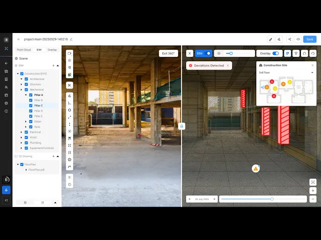
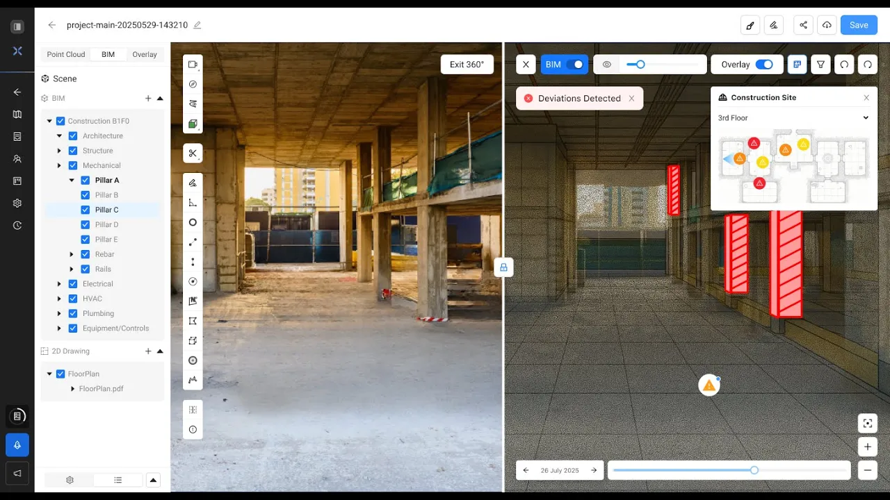
BIM Comparison
Comparer between your IFC models and current site point clouds. Use the deviation heatmap to identify mismatches instantly and mark issues directly on the model.
BIM Comparison
Comparer between your IFC models and current site point clouds. Use the deviation heatmap to identify mismatches instantly and mark issues directly on the model.
Team & User Management
Invite users with specific roles and organize them into teams; Monitor onboarding metrics; manage project access from a central Hub.
Team & User Management
Invite users with specific roles and organize them into teams; Monitor onboarding metrics; manage project access from a central Hub.
Issue Tracking & Management
Create issues directly in the 3D viewer. Assign teams, set priorities, and track resolutions through synchronized analytics boards.
Issue Tracking & Management
Create issues directly in the 3D viewer. Assign teams, set priorities, and track resolutions through synchronized analytics boards.
Site Survey
Create dated entries for point clouds, BIM, and 360° imagery. Navigate via sortable grids, verify metadata positioning; overlay view to compare progress.
Site Survey
Create dated entries for point clouds, BIM, and 360° imagery. Navigate via sortable grids, verify metadata positioning; overlay view to compare progress.
25
%
Faster Inspection
Inspections done in record time
25
%
Faster Inspection
Inspections done in record time
30
%
Less Rework
Fewer errors, lower costs
30
%
Less Rework
Fewer errors, lower costs
75
%
Data-Driven
Smarter decisions, backed by analytics
75
%
Data-Driven
Smarter decisions, backed by analytics
25
%
Cost Saving
Reduce hidden project expenses
25
%
Cost Saving
Reduce hidden project expenses
25
%
Faster Inspection
Inspections done in record time
10
%
Data-Driven
Smarter decisions, backed by analytics
30
%
Less Work
Fewer errors, lower costs
30
%
Cost Saving
Reduce hidden project expenses
Be among the first
ones to try SpatialSense
Join the SpatialSense and see how centralized spatial data, easy onboarding, and streamlined workflows give you an edge over traditional tools.
Be among the first
ones to try SpatialSense
Join the SpatialSense and see how centralized spatial data, easy onboarding, and streamlined workflows give you an edge over traditional tools.